Voxelization, Sensor Generation, and Shading Pipeline
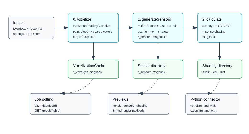
This guide explains the source-backed workflow exposed by the voxel-shading API and Python connector.
Related API References
- Python reference:
voxel_shading - Web reference:
VoxelShadingController - Main endpoints:
POST /api/voxelShading/voxelizePOST /api/voxelShading/generateSensorsPOST /api/voxelShading/calculatePOST /api/voxelShading/preview/voxelsPOST /api/voxelShading/preview/sensorsPOST /api/voxelShading/preview/shadingGET /api/voxelShading/job/{jobId}GET /api/voxelShading/result/{jobId}
Source Implementation
EnergyAtlasWeb/Controllers/VoxelShadingController.csEnergyAtlasLib/Preprocessing/TiledLidarVoxelization.csEnergyAtlasLib/Preprocessing/TiledSensorGeneration.csEnergyAtlasLib/Preprocessing/TiledSensorShading.csEnergyAtlasCore/VoxelShading/ShadingSensorGen.csConnectors/python/src/energyatlas/client.pyConnectors/python/src/energyatlas/models.py
Stage 0: LiDAR Voxelization
API: POST /api/voxelShading/voxelize
Inputs:
| Request field | Meaning |
|---|---|
lidarFiles |
One or more .las / .laz files. |
footprintFile |
Footprint GeoJSON path. |
outputDir |
Parent output directory; controller writes VoxelizationCache inside it. |
setting |
LidarVoxelizationSetting options. |
slicerSetting |
Optional tile slicing options. |
Important options:
| Option | Default | Notes |
|---|---|---|
resolution |
1.0 |
Voxel size in meters; validated as 0.25 to 5.0 in the controller. |
paddingDistance |
50 |
Tile context buffer for voxelization; validated as 0 to 200. |
kNeighbors |
4 |
Nearest neighbors for mesh draping interpolation. |
fillHoleWithMeanEdgeElevation |
false |
Ground-hole fill mode. |
resumeCacheExistsOnly |
false |
Fast resume mode by cache-file existence. |
tileSizeX, tileSizeY |
omitted | When both absent/null/nonpositive, native passthrough tiling is used. |
Outputs include per-tile *_voxelgrid.msgpack files, footprint summaries, metadata, and a run manifest.
Stage 1: Shading Sensor Generation
API: POST /api/voxelShading/generateSensors
Inputs:
| Request field | Meaning |
|---|---|
voxelCacheDir |
Directory containing *_voxelgrid.msgpack files. |
sensorOutDir |
Directory for *_sensors.msgpack; required by controller validation. |
genOpt |
Sensor-generation options. |
resolution |
Voxel resolution used by the worker. |
paddingDistance |
Tile context padding for loading voxel context. |
Generation behavior:
- Roof sensors are generated from draped roof mesh non-naked vertices.
- Roof sensor area weights are accumulated from adjacent face areas.
- Roof sensors are offset by
normalOffsetalong the vertex normal. - If
generateOnFacadeis true, facade sensors are generated between roof and ground along simplified footprint segments. - Facade sensors use
spacing,verticalSpacing,verticalOffset, andfacadeNormalOffset.
Options:
| Option | Default | Effect |
|---|---|---|
spacing |
1.0 |
Horizontal sensor spacing. |
verticalSpacing |
1.0 |
Facade vertical spacing. |
verticalOffset |
0.5 |
Facade vertical start offset. |
normalOffset |
sqrt(2) |
Roof sensor offset from surface. |
facadeNormalOffset |
1.74 |
Facade sensor offset from wall plane. |
generateOnFacade |
true |
Include facade sensors in addition to roof sensors. |
Outputs are tile sensor sets with sensor position, normal, area, roof/facade flag, building index, UBID, and surface id.
Stage 2: Shading Calculation
API: POST /api/voxelShading/calculate
Inputs:
| Request field | Meaning |
|---|---|
voxelCacheDir |
Voxel cache directory. |
sensorDir |
Directory containing *_sensors.msgpack. |
shadingOutDir |
Directory for *_sensorshading.msgpack; required by controller validation. |
latitude, longitude |
Required site coordinates. |
calcParams |
Shading calculation options. |
resolution |
Voxel resolution. |
paddingDistance |
Tile context padding. |
Calculation options:
| Option | Default | Effect |
|---|---|---|
calcUpdateFreq |
20 |
Days represented by each representative-day calculation. |
timeStep |
6 |
Calculations per hour; must divide 60. |
calculationRadius |
500 |
Ray-marching radius for sun/SVF/HVF occluders. |
skyDomeSamples |
512 |
Dome rays per sensor for SVF. |
horizonSamples |
24 |
Horizontal rays per sensor for HVF. |
calculateForDiffuse |
true |
Compute SVF/HVF for diffuse components. |
summarizeHourly |
true |
Average sub-hour sunlit fractions to hourly output. |
timeZone |
omitted | Defaults to round(longitude / 15) in the two-stage worker. |
Outputs are tile shading records with sensor metadata plus SunlitFraction, SkyViewFactor, and HorizonViewFactor.
Preview and Polling
preview/voxelsreads voxel cache and returns a limited point payload.preview/sensorsreads sensor files and can include normals.preview/shadingreads shading files and can select asunlitIndex.- Every long-running stage returns
{ success: true, jobId }. - Poll
/api/voxelShading/job/{jobId}for status. - Fetch
/api/voxelShading/result/{jobId}for manifest-like output after completion.
Python Connector
The connector exposes the same workflow under client.voxel_shading:
1 2 3 | |
It also exposes direct voxelize, generate_sensors, calculate, preview, job, and result calls for custom polling.